
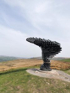
Billed as one of the most iconic artworks in Lancashire, the Singing Ringing Tree, high on the moors above Burnley, is one of four local Panopticons and consists of a unique musical sculpture in the form of a wind-blown tree. The Tree, along with the attraction of reaching the summit of Thieveley Pike, makes for an enjoyable though challenging 5½ mile hike with wonderful views.
The starting point of the walk is the car park near the Singing Ringing Tree and the nearest postcode is BB11 3RT. Follow the single track from the car park to the clearly visible sculpture in the distance and once you’ve done the ubiquitous selfies, head past the sculpture and over the stile. Before you reach the next dry-stone boundary, look to the left for the pathway winding through moorland and pick up the trail downhill.
Clamber over the loose stone entrance to the next field and follow the left-hand perimeter of that rough field as much as you are able. Navigate your way round the left of the hollow and carry on downhill towards the steel bar gate next to the cottage. Go through the gate and follow the extremely steep driveway to its conclusion with the main Bacup Road (A671) by Heyne Farm.
Turn right, cross over and look out for the footpath sign on the left. Take the steps downhill and stay on the left-hand side of the brook for a few steps, and then cross the brook and follow the downhill path towards Dyneley Farm. Go down the stone steps to the track and turn right.
Follow the path, meandering gently downhill and passing straight through Stone House Fold, still heading towards the wind turbines in the distance until the next farm appears: Scout Farm. Walk along the path at the front of the farm and then when you reach the stone track, turn left towards a phone mast for 50 yards or so until the path forks just before the mast; take the lesser-used right fork along a dirt track.
Pass through the wooden fence and carry on this path, which runs parallel to the railway track. You’ll eventually pass underneath the track and, when you have done so, turn right. Follow that track to a slanted T-junction; then turn right and take a tunnel under the railway once more.
And so, it starts; the sheer hell of a climb from 650 ft to just over 1450 ft in one stretch. Follow the winding stone path uphill and just before you get to Buckley’s Farm, take the public footpath on the right into Buckley Wood.
Follow the well-defined path up the side of Buckley Wood until you reach the first plateau where a few paths converge. Carry straight on uphill (there’s a small Thieveley Pike sign on the fence) until you reach the track that signifies the second plateau. And there on Deerplay Moor the pathways peter out somewhat, so just head uphill in the same direction and you’ll eventually arrive at the white pillar (trig point 6438) at the top of Thieveley Pike.
After giving yourself a big pat on the back for making it to the top, turn right along the fence boundary and then cross over a stile into the next field and carry on in the same direction. Follow the path for almost a mile, navigating Black Clough gorge on the way, through a stone gateway and following the path on the right-hand perimeter of a field which eventually curves left and runs parallel to the A671.
Once you get onto the road from the field, turn right, cross over and then walk ¼ of a mile and at the T-junction, turn left to Rawtenstall and then immediate right into Crown Point Road. Follow this road for 230 yards and then take a left turn into a short road by the Dunnockshaw Community Wood sign.
Once you’ve walked about 25 yards of the short road, hop over the stile on the right and continue through the well-maintained woodlands for ¾ of a mile until you reach the car park from where you started the walk.